When you are out at sea, floating around aimlessly after your boat has sunk, it can be an extremely frustrating and frightening situation. You and your life raft are less than a speck on the surface of the greatest watery desert on the face of this Earth and chances are slim that you can be seen by rescue parties ... even if your exact location is known. Due to the winds and the currents and the fact that are entirely dependent on the prevalent weather conditions, you will be drifting. For instance, if the winds and currents are blowing at 5 kmph, you will drift more than a hundred kilometres a day. That means the search parties have to expand their search perimeter over a 10,000 sq km area. Needless to say, your chances of being found are less than a needle in a haystack.
But hope endures and you have do whatever is in your power ... and then some ... to make the best possible effort to get rescued or maybe even to rescue yourself by finding the closest land mass. Even if it an uninhabited island, your chances of survival are far greater on land that at the mercy of the open sea.
To be able to navigate, you will need to know where you are and in which direction you need to head. Yes, you can try and steer a life raft. There are emergency paddles in life rafts. You can rig up a sail. You can curtail drifting in the wrong direction by deploying your sea anchor. There are things you can do. But how do you know you are heading in the wrong direction. For that you will need to know the “right” direction in the first place ... where you are reference to where land is, etc.
Knowing your latitude is by far one of the most important pieces of information that will help you navigate towards help, rescue and safety.
Unfortunately, life rafts do not come equipped with sextants. With a modern sextant or a GPS system, you will know your coordinates. But like I said, sextants are not part of standard life raft survival kits. But you can improvise one with stuff that you will find in the life raft or in your survival kit. What you require are three lengths of anything stiff, each about six to eight inches long, thinner the better.
But before we go ahead and improvise a sextant, let us first figure out how it works and what it is supposed to do.
A sextant is an instrument that assists you in determining your latitude, using the horizon and the stars, namely the North Star or Polaris. The North Star is called such since (1) it is the only star that does not move in the sky providing you with a fixed point of reference, and (2) it sits directly above the North Pole. If you were standing AT the North Pole, Polaris would be directly overhead, at 90º; the horizon is at 0º. Alternatively, if you were standing at the Equator, you would find Polaris kissing the horizon at 0º. Which means that anywhere between the Equator and the North Pole, the degrees at which you will be able to place the North Star will vary between 0º and 90º. The trick is to arrive at this angle accurately and once you have done that, you will know your latitude.
This is what the sextant enables us to do.
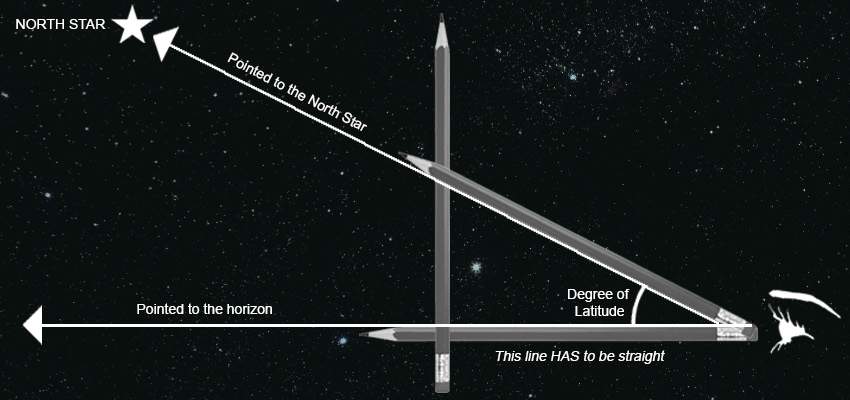
Now to rig up a sextant. You need length of something rigid and straight. Tie two of these lengths together at one end so that they are at right angles to each other. The horizontal length point to the horizon while the vertical length points straight up at the sky. Tie the third length to these two pieces to make a right angled triangle. You have your sextant ready for use.
Point the horizontal piece directly at the horizon keeping it parallel to the surface of the sea. This is the tricky part. Your raft will be pitching and rolling and bobbing about in the waves. Keeping a straight horizontal position with your sextant will be difficult. But try you must. The vertical piece is away from you and the hypotenuse is tied to the vertical and dropping towards your eyes where it is tied to the horizontal piece. Lower or raise the end that is tied to the vertical piece till your eyes at the end of the piece, the length of the hypotenuse and the North Star are in one straight line. Ensure that the horizontal is still absolutely parallel to the surface of the ocean. Once you have the straight line going from your eyes, down the length of the hypotenuse, all the way to the North Star, fix this position so that the angle does not change.
Open up your map or chart and using the compass rose on it, measure the angle formed by the hypotenuse and the base of the triangle.
The angle produced is your degree of latitude.
Take a reading frequently so that you know your heading. Try and keep as close to your heading as possible using the readings you get from your sextant. If you want to stay on a 26ºN latitude, your sextant will tell you if you are veering off course.
The problem with using the North Star is that you can only do so at night ... and on a clear night at that. However, you can also use the sextant during the day and use the same method of determining latitude using the Sun. The lay of the sextant will vary slightly.
But before you use the Sun, you will need to know what time NOON is at your location. You can determine that using the shadows cast by the Sun. At the time the shadow cast by the Sun is the shortest, is the time when it is noon at your location. It is at precisely this time that you need to determine your latitude. Any other time of the day and you will go horribly wrong!
The base of the triangle becomes your vertical. Point it directly skywards. Slide the hypotenuse to the point where the shadow created by the Sun falls on its own footprint. Meaning there is no shadow of the hypotenuse. Determine the angle formed by the hypotenuse and the vertical. That is your latitude.
It is not easy and if you go wrong by even a millimetre or so, your calculation will be wrong. A miscalculation of even one degree of latitude will mean an error of 111 km. It can mean the difference between making landfall or missing it entirely and drifting off into the vast nothingness beyond.
But, using a sextant you can determine your latitude and that information could finally make the difference between whether you live or you die.


Zuly
You can use a sextant to mauesre the angle between a star and the horizon. Imagine you were at the north pole. If you looked straight up you would see the north star. As the earth spun, that star would stay right where it was, and everything would spin around it. It would be at a 90 degree angle with the horizon (assuming no hills, etc.). As you move south, it would get closer to the horizon. By measuring the angle between the north star and the horizon (which is what a sextant does) you can calculate your latitude. EDIT: Measuring the angle to the north star *might* not work in the south pacific depends how far south you are. If you are waaayyyy south you may not be able to see the north star but even in that case you can still use the angle to some other well known celestial body (possibly in combination with the date and time) to make the same calculation.Longitude is trickier, but based on a similar principle. Chronometer is just a fancy word for a very accurate clock. You are probably familiar with time zones, so you realize that sunrise and sunset occur at different times depending on your longitude (east/west position). While it may be dark on one part of the planet, it’s light on another. You also probably realize that you can predict *exactly* what time the sun will rise tomorrow if you know your particular longitude. (It doesn’t have to be sunrise you could also use sunset, moonrise, some star rise, etc.) However, if you travel east or west those times will be shifted which is why we reset our watch when we change time zones. If you travel half way around the world, the sun would rise 12 hours later than if you stayed right where you are.If you have an accurate clock (chronometer) you mauesre what time the sun *actually* rose where you are at and compare this to the time for the same event at a known longitude. The difference between the time the sun rose where you are at, and the time the sun rises at some known longitude tells you how far east or west you’ve traveled around the globe from that location. For example, suppose where you are at the sun rose 1 hour later than it normally does at the place you are from then you know you are 1/24 of the way around the globe from that starting location because there are 24 hours in a day and you are 1 hour shifted hence 1/24. (It’s because of this timing mauesrement that there are minutes and seconds part of the longitude scale.)